 Hello, we are Myouken and Hatazoe from the Converging Technologies Laboratory. We have developed technologies that support "high-quality, rapid visualization of the ocean environment" and "multifaceted policy planning and implementation" for initiatives such as the environmental conservation of blue carbon ecosystems [*1], which are expected to contribute to decarbonization and the preservation of the ocean environment. By leveraging these technologies, we have successfully obtained J-Blue Credit® [*2] certification [*3]. In this article, we will introduce the technologies that constitute "high-quality, rapid visualization of the ocean environment."
(This blog is translated by AI)
Introduction
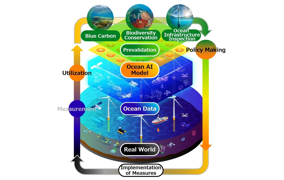
Fujitsu has committed to addressing global environmental challenges as one of our Materialities (key issues) for sustainable growth. We are actively engaged in initiatives for climate change (carbon neutrality) and coexistence with nature (biodiversity conservation). As part of these efforts, we are advancing the research and development of an Ocean Digital Twin, which digitally reproduces the state of the ocean to predict changes. We are particularly focused on blue carbon and blue carbon credits, which involve measuring and quantifying the amount of blue carbon and trading it as credits, as they are expected to contribute to carbon neutrality and biodiversity conservation. Currently, creating blue carbon credits requires underwater surveys by divers and analysis by experts, which presents a challenge due to the significant time involved. Furthermore, there are limits to ensuring the accuracy of manual measurement, recognition, and quantification due to the harsh ocean environment, including underwater turbidity, waves, and currents, as well as the vast amount of ocean data to be handled.
To address this challenge, we have developed two core technologies: "Underwater Drone Automatic Navigation Control Technology," which enables underwater data measurement with a positional accuracy of within plus or minus 50 cm even in ocean currents, and "Seaweed and Seagrass Beds [*4] Quantification Technology," which recognizes the species and coverage [*5] of seaweed and seagrass beds with high accuracy of over 85%. By utilizing these technologies, we have built an end-to-end system [*6] (hereinafter, this system) that supports the acquisition of blue carbon credit certification by measuring and quantifying 100 times faster (approximately 30 minutes per hectare).
Developed Technologies
1. Underwater Drone Automatic Navigation Control Technology
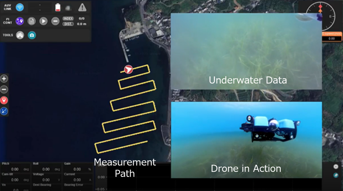
By leveraging our extensive expertise and control technologies cultivated over many years in the development of hardware such as robots and HDDs (Hard Disk Drives), we have developed an automatic navigation technology for underwater drones. This technology enables the drone to navigate underwater automatically and stably, unaffected by fluctuations from ocean currents or complex terrain. Specifically, the underwater drone can stably navigate along a designated measurement route on a map with a positional error of within plus or minus 50 cm from the route, allowing for comprehensive measurement, including near reefs (see Figure 2). This has enabled the rapid and automatic measurement of underwater data.
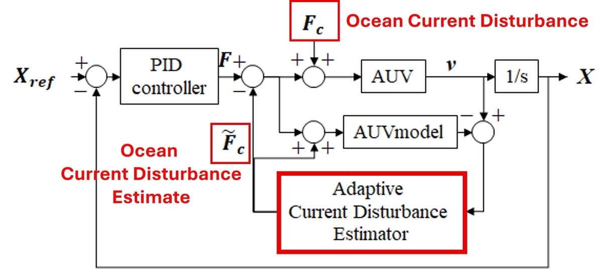
The position control of the underwater drone is based on the difference between the target values (latitude, longitude, bearing, and underwater altitude in four directions) and the drone's current position and orientation information, performing independent PID control [*7] for each of the four directions. Particularly for the latitude and longitude directions, we estimate the ocean current disturbance from the difference between the drone's actual velocity and its model velocity and add this to the control system in advance, effectively reducing the impact of ocean currents (see Figure 3).
2. Seaweed and Seagrass Beds Quantification Technology
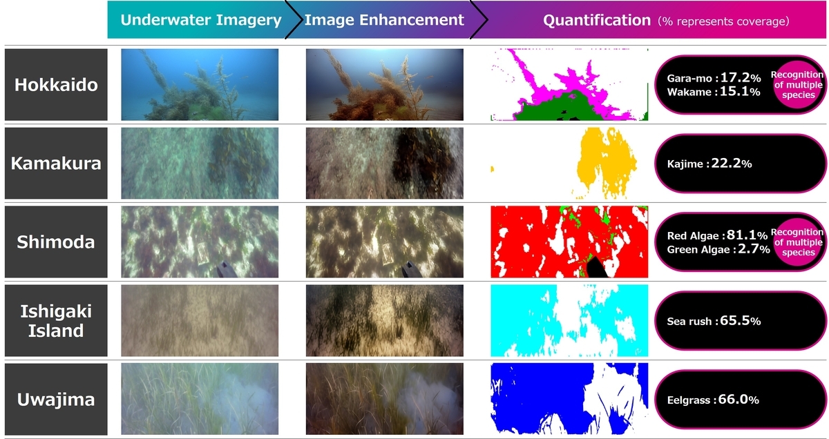
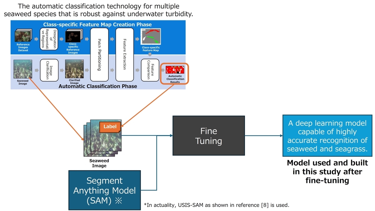
We have developed a technology that integrates ocean ecology and computer vision to recognize and quantify the species and coverage of seaweed and seagrass, even in turbid underwater conditions. Not only can this technology restore the color and contours of objects from images made unclear by underwater turbidity using image enhancement technology, but it can also recognize the species and coverage of seaweed and seagrass with high accuracy of over 85% from the shape and color of the enhanced objects. Furthermore, by using a technology that mathematically models the amount of blue carbon absorbed by different types and coverages of algae, we have also achieved the quantification of blue carbon in vegetated areas. It also supports recognition under conditions where multiple algal species are mixed (see Figure 4), making it possible to cover 80% of Japan's sea areas.
Specifically, we apply enhancement processing to images taken at a close range of within 0.5m from the seaweed and seagrass, and from these clear images, we create class-specific feature maps that serve as the basis for automatic classification for each seaweed and seagrass species. By comparing and classifying these class-specific feature maps with the captured images and fine-tuning the Segment Anything Model [*8], we have constructed a deep learning model capable of recognizing coverage with high accuracy (see Figure 5).
Future Prospects
Looking ahead, we will focus on applying the developed technologies and this system to real-world ocean environments. By collaborating with local governments and businesses in each region, we will promote the use of these technologies for the restoration and conservation of seaweed and seagrass beds and to support the acquisition of J-Blue Credit® certification, thereby aiming to realize a Nature Positive world. We will also expand the application areas of the developed technologies to include inspections of ocean infrastructure such as offshore wind power generation, which holds high expectations for decarbonization, and environmental surveys before and after ocean construction projects. In this way, we will advance the technological evolution of the Ocean Digital Twin, build partnerships with companies, municipalities, and organizations engaged in activities such as carbon neutrality and biodiversity conservation, and aim to establish a business by 2027 that successfully balances environmental conservation with economic growth.
Related Links and Footnotes
- PRESS RELEASE Fujitsu accelerates blue carbon certification with ocean digital twin technology
- Fujitsu Research Portal Nature-positive through Ocean Digital Twin technologies
*1:ecosystems that absorb and store CO2 in the ocean, such as seaweed and seagrass beds, salt marshes/tidal flats, and mangrove forests
*2:a type of carbon credit issued by the Japan Blue Economy Association for projects utilizing blue carbon
*3:Uwaijima Initiative! Collaborative Blue Carbon Project for Eelgrass Restoration by Fisheries Cooperatives, Communities, and Local Government(Japanese)
*4:areas where seaweed and seagrass grow densely
*5:the percentage of the seafloor covered by seaweed and seagrass
*6:a system that manages a process from beginning to end
*7:PID control is one of the most widely used control methods in automatic control. It determines the control input based on the deviation between the reference input (target input) and the output at each point in time.(Japanese)
*8:S. Lian et al., “Diving into Underwater: Segment Anything Model Guided Underwater Salient Instance Segmentation and A Large-scale Dataset,” ICML, 2024.